| Itinerary | WAY OF THE RURAL CHURCHES - Itinerary 2: Poggio Sannita - Belmonte del Sannio |
|---|---|
| Region | |
| Start point | |
| Difficulty | |
| Lenght | |
| Walking time | |
| Height difference | |
| Maximum Quota |
Course description
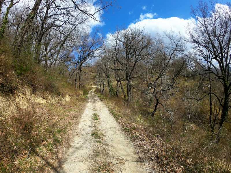
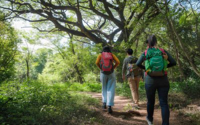
Respectively overlooking the Verrino and Sente streams, Poggio Sannita e Belmonte del Sannio are connected by this quiet trail that takes us to visit the small hamlet of Villa Canale in Agnone and the characteristic hamlet of Masseria Belladonna. The trail presents no difficulty, the bottom is mixed with a few short passages of now-forgotten tracks. The Tratturello “Castel del Giudice-Pescolanciano“ will be traveled for a very short distance, then we will turn in the direction of Villa Canale. This tiny hamlet is an ideal place for a relaxing short stop where you can be captivated by the view and quiet of the place. The path resumes by returning, for a short distance, to our steps until we reach
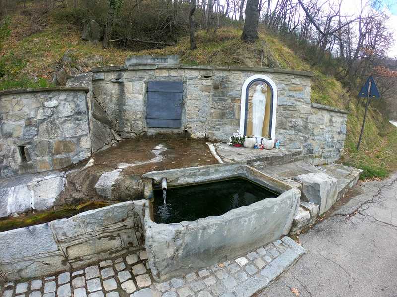
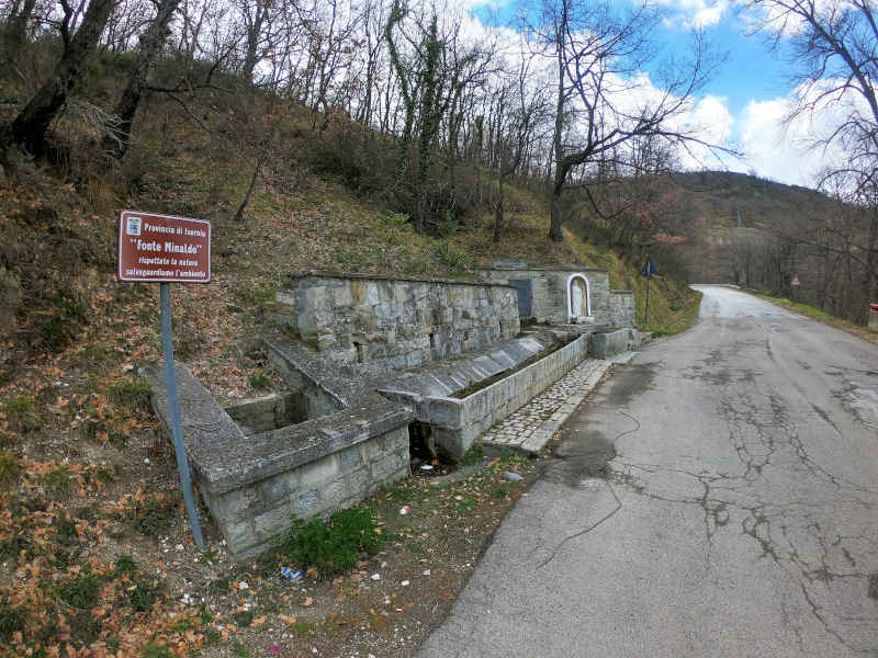
Fonte Minaldo, we leave the asphalt and cross the Tratturello again to head toward the other valley, that of Torrente Sente. Imperceptibly the atmosphere seems to change, as does the vegetation; immediately we encounter the Masserie Belladonna farms nestled and hidden in the shadow of “Pietra Corva” on Mount Villanelle, the only obstacle separating our view from the end of the stage. Over the last drop on a sandstone and gorse mule track and magically we are at the gates of Belmonte del Sannio.

Useful information
Equipment and practical advice
EQUIPMENT
To optimize your equipment, carefully read information about the route to be taken and the weather and climate forecast. This could be a list of basic equipment:
backpack suitable for real needs – At least 1L of water (2 in warm months/hot drink in winter) – Hiking map – guide – sunglasses – multifunctional penknife – head flashlight – smartphone battery charger – powerbank – camera – insect repellent – first aid kit – rain jacket – airtight bag for valuables and clothing to keep dry in case of rain – bag for trash – anti inflammatory ointment – personal medication.
Bring some light and nutritious food such as dried fruits, chocolate bars, candy, honey (energy snack). Pack your lunch in advance or be sure to pass through a town in case you need supplies. Bring trekking poles that assist in pushing uphill and help with stability on rough trails. The presence of streams and wooded trails makes some trails impassable and very muddy in heavy rains. High, waterproof hiking shoes are essential here, along with good quality (breathable) socks, which should never be underestimated! Your clothing should not lack: Windbreaker/waterproof jacket; Hat; Gloves for low temperatures.
TIPS & BEHAVIOR
Although it may seem superfluous, we recall the need to behave properly and respectfully toward others and the environment, each person making his or her own contribution by bringing back with them what would harm the environment. The path can be walked all year round, but of course spring and autumn offer the best weather and landscape conditions. For many high stretches, periods of large winter snowfall should be avoided, and in the hottest summer period, water supply and travel time should be well calculated to move during the milder hours and stop during the hottest hours. The path is well marked with comfort flags and marker arrows.
Let’s not damage the plants, let’s remember that we walk through protected environments that need to be protected. We do not light fires. We keep dogs on a leash or harness, mandatory in protected areas. We do not abandon waste. We prevent all fire hazards. We also take into account that some trails may be challenging in bad weather conditions. We always follow the official trails and when in doubt turn back to the last marked trailhead. In Molise, free camping is prohibited in certain areas, therefore, facilities that can accommodate must be used.
CAI Classification of Routes
Italian Alpine Club classification of routes according to difficulty in hiking and cycling
EXCURSION SCOPE
T = Tourist
FEATURES
Routes on cart tracks, mule tracks or obvious paths that pose no uncertainties or problems of orientation, with modest inclines and moderate elevation changes.
SKILLS AND COMPETENCIES
Require basic hiking knowledge and physical fitness for walking.
EQUIPMENT
Appropriate clothing and footwear are still required.
E = Hiking
FEATURES
Routes that represent the majority of hiking routes, thus among the most varied in terms of natural environments. They take place on mule tracks, trails and sometimes tracks; on different terrain by geomorphological and vegetation context (e.g., pastures, undergrowth, debris, scree). They are generally marked and may have steep sections. Easy, unexposed rock passages can be encountered that require the use of hands for balance. Any exposed spots are usually protected. They can cross flat or shallowly sloping areas on residual snow.
SKILLS AND COMPETENCIES
They require sense of direction and hiking experience and adequate training.
EQUIPMENT
Suitable equipment with special regard to footwear is required.
EE= Experienced hikers
FEATURES
Nearly always marked routes that require ability to move along trails and tracks over impervious and/or treacherous terrain (steep and/or slippery slopes of grass, rocks or stony debris), often unstable and uneven. They may have exposed sections, traverses, ledges or rocky sections with slight technical difficulties and/or equipped, while via ferratas proper are excluded. They are developed on medium to steep slopes. Crossing sections on snow may be necessary, while all glacier routes are excluded.
SKILLS AND COMPETENCIES
Need excellent hiking experience, orienteering skills, knowledge of the characteristics of the mountain environment, sure-footedness and absence of vertigo, evaluative and decision-making skills as well as adequate physical fitness.
EQUIPMENT
Require appropriate equipment and gear for the planned itinerary.
EEA = Experienced hikers with equipment
A ferrata is defined as a route whose sections on rock are specially equipped with metal structures: cables, chains, ladders, pegs and stirrups, which facilitate and enable its progression. They provide for the use of personal protective equipment certified according to current regulations (harness, via ferrata kit and helmet) and adequate technical preparation. They are marked at the start by special signs and meet precise construction and regulatory criteria.
Points of interest
Church of Our Lady of Grace
The building of this temple, which took place around 1590, was due to feudal lord Giovanni de Raho. The church, the chronicles report, was renovated for reasons of stability as early as a few years after its founding and on several occasions in the following centuries. In particular, the original nave was flanked by the two side aisles precisely to improve its stability. There are few original artistic and architectural elements. Twentieth-century are the portico and buttresses. In 1720 a strong earthquake shook Abruzzo and Molise. The parish church of St. Victoria virgin and martyr was reduced to ruins, and the seat of the parish for five years was the extra moenia church, which housed the valuable 16th-century Neapolitan-made statue of the saint. The church is reached every year by devout Poggese on March 25, the Feast of the Annunciation. An object of great veneration was and still is the recently restored early 19th-century wooden statue depicting Our Lady of Grace kept in the parish church.
Box trivia: In various localities at the Feast of the Annunciation it was suggested that a ritual be practiced for the healing or prevention of hernia. The local declination of the rite involved the boys reaching the little church by passing through fields covered by brambles.
3D Map
The linked App is not related to the website, but provides additional convenience in using the presented content. Its use is voluntary. If the app is not yet installed on your device, you will be redirected to the corresponding App Store.
Poggio Sannita – Belmonte del Sannio
(km 8.59)
Itinerary 2
Departure: Poggio Sannita
Arrival: Belmonte del Sannio
Distance: 8.59 kilometers
Walking time: 2 hours
Difficulty: Tourist
Height difference: +450 -300
58% asphalt – 14% cart tracks – 28% gravel.
Cyclability: Yes
Recommended Period: Spring, summer, autumn
GPX files: Download
![]()
![]()
![]()
![]()
![]()
Frame or click the QR code and open the Web App

It should be noted that the routes may include sections where vehicular traffic is concurrent.
Photographs
Other Itineraries
![]() I1: Civitanova del Sannio – Poggio Sannita
I1: Civitanova del Sannio – Poggio Sannita![]() I2: Poggio Sannita – Belmonte del Sannio
I2: Poggio Sannita – Belmonte del Sannio![]() I3: Belmonte del Sannio – Agnone
I3: Belmonte del Sannio – Agnone![]() I4: Agnone – Capracotta
I4: Agnone – Capracotta![]() I5: Capracotta – Pescopennataro
I5: Capracotta – Pescopennataro![]() I6: Pescopennataro – Sant’Angelo del Pesco
I6: Pescopennataro – Sant’Angelo del Pesco![]() I7: Sant’Angelo del Pesco – Castel del Giudice
I7: Sant’Angelo del Pesco – Castel del Giudice![]() I8: Castel del Giudice – Capracotta
I8: Castel del Giudice – Capracotta![]() I9: Poggio Sannita – Castelverrino
I9: Poggio Sannita – Castelverrino![]() I10: Castelverrino – Agnone
I10: Castelverrino – Agnone
Highlights
Some sections of the Way are impassable due to dense vegetation.
I percorsi n° 7, SANT’ANGELO DEL PESCO – CASTEL DEL GIUDICE, e n° 9 POGGIO SANNITA – CASTELVERRINO, sono attualmente impercorribili a causa della vegetazione molto rigogliosa che ne impedisce la percorrenza in ampi tratti. Altri percorsi, il n° 2 POGGIO SANNITA –...
Some sections of the Way are impassable due to dense vegetation.
Routes No. 7, Sant'Angelo del Pesco – Castel del Giudice, and No. 9, Poggio Sannita – Castelverrino, are currently impassable due to the very lush vegetation that prevents travel along large sections. Other routes: No. 2 POGGIO SANNITA – BELMONTE DEL SANNIO, No. 3...
Some sections of the Way are impassable due to dense vegetation.
I percorsi n° 7, SANT’ANGELO DEL PESCO – CASTEL DEL GIUDICE, e n° 9 POGGIO SANNITA – CASTELVERRINO, sono attualmente impercorribili a causa della vegetazione molto rigogliosa che ne impedisce la percorrenza in ampi tratti. Altri percorsi, il n° 2 POGGIO SANNITA –...

The “Walk of the Country Churches” is an outdoor trail of about 90 kilometers connecting 9 historical centers e 15 small churches scattered throughout the territory of Agnone, Belmonte del Sannio , Capracotta, Castel del Giudice, Castelverrino, Civitanova del Sannio, Pescopennataro, Poggio Sannita e Sant’Angelo del Pesco.
© The Way Of The Country Churches | Project | Credit | Privacy Policy | Cookie Policy | Contact
INITIATIVE FUNDED BY THE FEASR – European Agricultural Fund for Rural Development – PSR Molise Region 2014 – 2020


